
Last updated on September 18th, 2026
Editor's Note
On August 26, 2026, an ice-rock collapse occurred in the high Himalayan region of Nepal, triggering large-scale debris flows and mountain torrents that flowed down the Dongling Zangbo River(Lhende River), bringing huge destruction and causing mass casualties in the China-Nepal border area. The 24 hours following such a disaster is a critical window for emergency rescue work, but is also a peak period for the spread of misinformation. The sudden onset of disaster, limited on-site information and delayed cross-border information verification can easily lead to fragmented and inaccurate information bring shared among the public. X account @RealBababanaras used border port footage to fabricate a “Chinese dam collapse” story, tied it to Nepal’s missing data, and falsely claimed it caused the deadly Nepal floods—without any official corroboration. The spread of such misinformation on overseas platforms can easily influence the outside world’s objective perception of regional infrastructure and cross-border disaster prevention cooperation and interfere with transnational emergency rescue efforts. This report systematically presents and dissects the whole chain of this false narrative and its dissemination.
It should also be pointed out that natural disasters know no national boundaries, and cross-border disaster prevention, emergency cooperation and post-disaster governance are common challenges shared by all impacted countries and regions. After this mudslide and flood disaster, China and Nepal actively carried out information sharing, joint search and rescue, and joint risk prevention and control. In the cross-border dissemination of public opinions related to disasters, facts and truth related to the immediate rescue operation, humanitarian relief and post-disaster reconstruction efforts should rightly become the core concerns of the public.
Claim
Within the first 24 hours after the disaster struck on Aug. 26, as on-site communications were cut off and details remained unclear, a batch of misinformation began to emerge on overseas social media. X platform account @RealBababanaras posted two consecutive posts within 30 minutes consecutively as follows: At 18:41 Beijing Time, the first post claimed, “Nepal afterflash floods reportedly originating from Tibet, following the collapse of a Chinese dam”; At 19:09, a second post continued, “This flooding is reported to have occurred after the collapse of a Chinese dam in Tibet, 291 foreign tourists are missing, including 105 Indians, 38 US citizens…” The core narrative of the two posts, that mountain torrents were caused by a Chinese dam collapse, relies on manipulated video footage, as the original surveillance footage was edited and spliced to construct a misleading narrative.
As of September 6, the two posts had accumulated a total of 640,000 views, and the relevant repost garnered 250,000 views, with the total number of reposts and comments standing at 418 and 323 respectively. Further assessment reveals that among the accounts that participated in comments and reposts, there was also a communication tendency to attribute natural disasters to Chinese projects. While criticizing Chinese projects, they also steered the discussion into the political realm with claims that lack factual support.


Fact Check
This misinformation uses the surveillance video of the Gyirong Port on the China-Nepal border as a visual point, fabricates the plot of the collapse of the Chinese dam, and further assembles the pseudo-causal chain of “the collapse of the Chinese dam causing Nepal’s flash floods and casualties”. The narrative was first spread by the X platform account @RealBababanaras @BlacksmithIndie within 24 hours of the disaster and then forwarded and commented on by multiple Indian ID accounts, forming a multi-level referral spread across accounts .
1. Why Did the First 24 Hours After This Disaster Become a Window for Misinformation?
The disaster struck the China‑Nepal border, a geopolitically sensitive region with transboundary rivers that naturally draws public attention and speculation after natural disasters.
Fact Hunter consulted Professor Kang Qiujie from the Communication University of China. She noted that as this was a climate‑induced cross‑border disaster, verifying its exact causes requires careful bilateral coordination, which lengthens the investigation time and chain of official information and raises verification costs, thus prolonging the “fact gap”. This “information vacuum” or “fact gap” creates a prime window for misinformation to take hold. In the first 24 hours, when official information is scarce but public demand is high, the void is rapidly filled with unverified content. Misinformation needs no verification—a blurry video alone can piece together a “dam‑collapse‑caused‑floods” story and enter the dissemination chain within a matter of minutes.
2. What Exactly Is This Video—and What Was It Edited to Look Like?
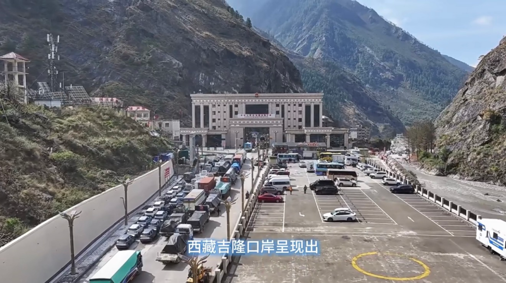
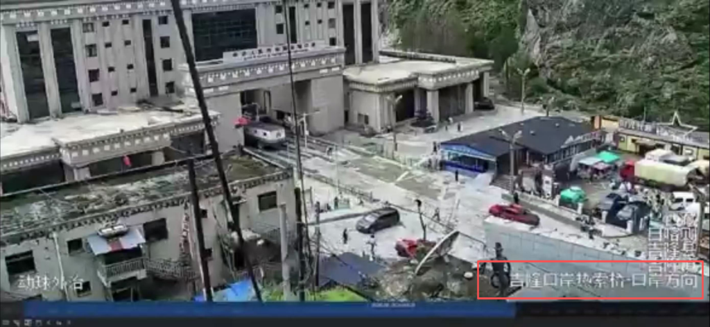
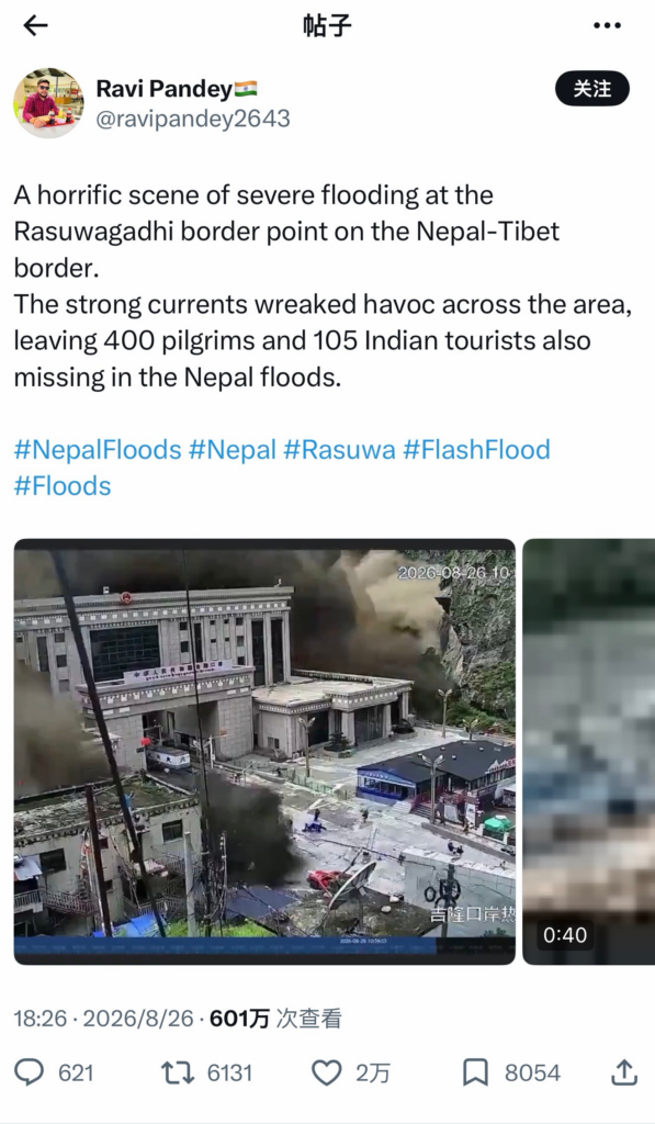
This ” China Dam Collapse” narrative is based on a video of the Gyirong Port being submerged. After comparing with the video released by the Gyirong Entry-Exit Border Inspection Station WeChat Channels, the main building in the video is beige colored, with a national emblem on the top, and a plaque reading “Gyirong Port of the People’s Republic of China” hanging above the doorway. The port is located in a high mountain valley, with outposts, signal towers and other buildings on the left slope, and a customs clearance lane in front. These buildings have characteristics consistent with the Gyirong Port image released by the “Gyirong Entry-Exit Border Inspection Station WeChat Channels. Based on this, we can determine the video was shot at the Gyirong Port. However, the video does not contain any structures related to a dam or the process of a dam failure, so it cannot serve as visual evidence for the claim made in the post of a “Chinese dam collapse”.
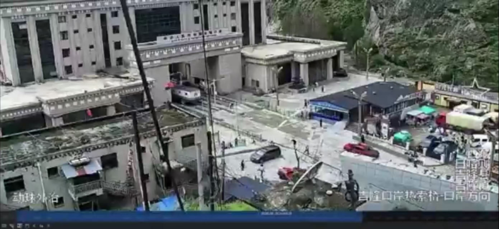
Further verification found that when user @RealBababanaras posted the silent surveillance footage, he also added rather urgent background music and concealed the time watermark of the video. In contrast, when the British Broadcasting Corporation (BBC) released this video, it clearly stated in the post and the video that editing had been carried out, and used white flashes to block some potentially disturbing and sensitive footage. The version released by the BBC retained the original time watermark, marked that “the original footage has no sound”, and kept it in a silent state.
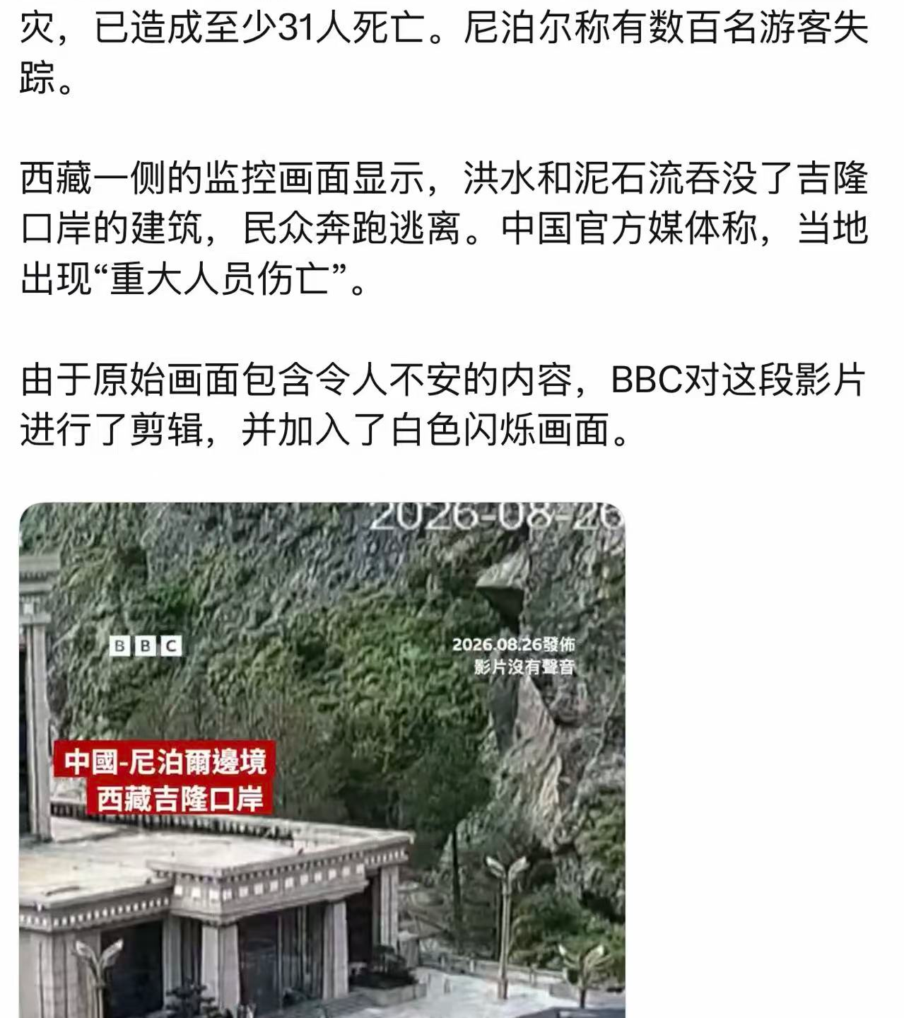
On the X platform, this video can be traced back at least as far as the post by user @MrGafish, whose version is silent and bears a time stamp. Media outlets including AFP and AP have also released the video, which shares the same format features — it is also silent and contains a watermark with a time stamp. However, none of the news agencies or social media users have marked its original source. It can thus be seen that this surveillance video, despite lacking a verifiable clear origin, has been widely spread on social media.
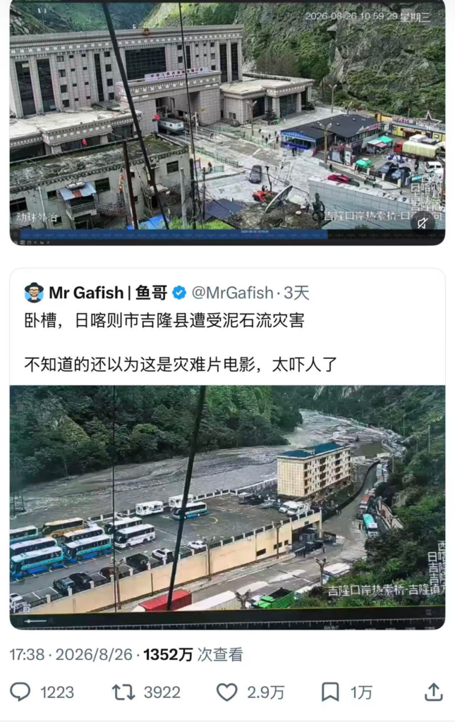
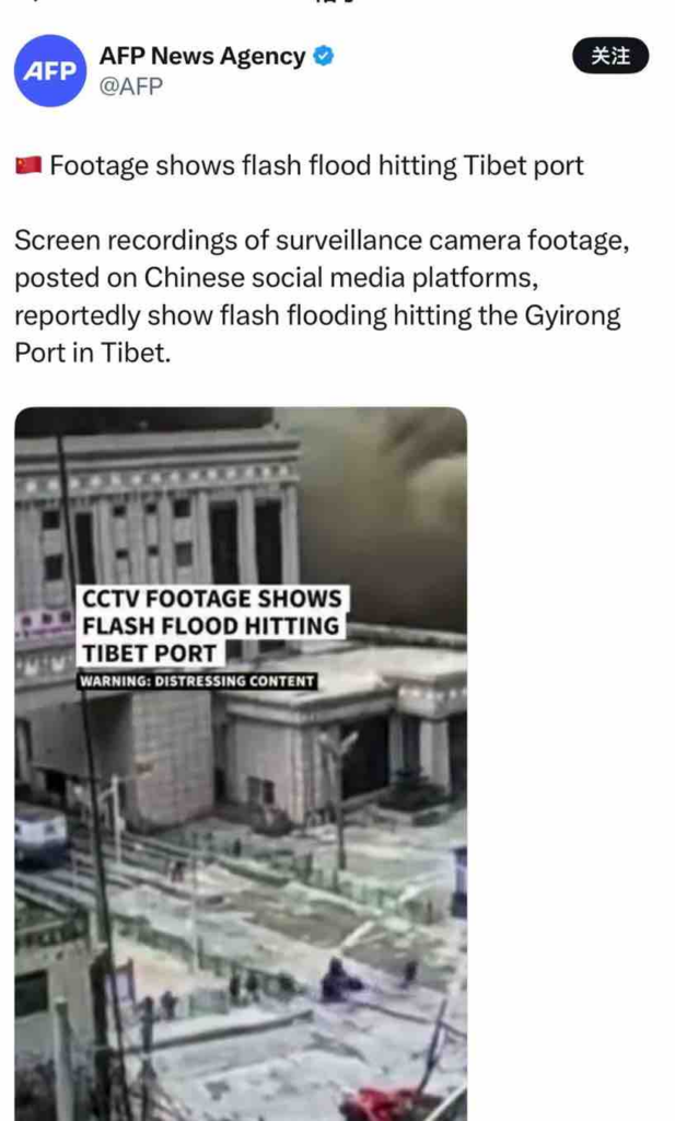
Regarding the source of this flood, multiple analyses point to the high mountain glaciers in Nepal. On August 28th, two days after the disaster struck, Binod Dhawadi, a professor at Tribhuvan University in Nepal, told the China Media Group (CMG) in an interview that the debris flow disaster originated at the Lirung Glacier in Nepal. Meanwhile, according to the Xinhua News Agency, relevant experts from China’s Ministry of Natural Resources also confirmed this judgment, noting that the disaster was triggered by the collapse of a high-altitude glacier in Nepal. In addition, the location information displayed in the lower right corner of the online-circulated video footage reads “Rasuwagadhi Port, Rasuwa Bridge – Port Direction”. Based on a comprehensive judgment combining the flow direction of the debris flow in the footage and expert analysis, the flood surged from the direction of the Rasuwa Bridge within Nepal.
According to the analysis of satellite imagery cited in a report by Reuters on Aug. 28, it can also be determined that the mountain torrents poured down from the direction of the Rasuwa Bridge on the Nepal side towards the downstream of the Chinese side’s Gyirong Port, rather than originating from southwest China’s Xizang Autonomous Region as claimed in online posts.
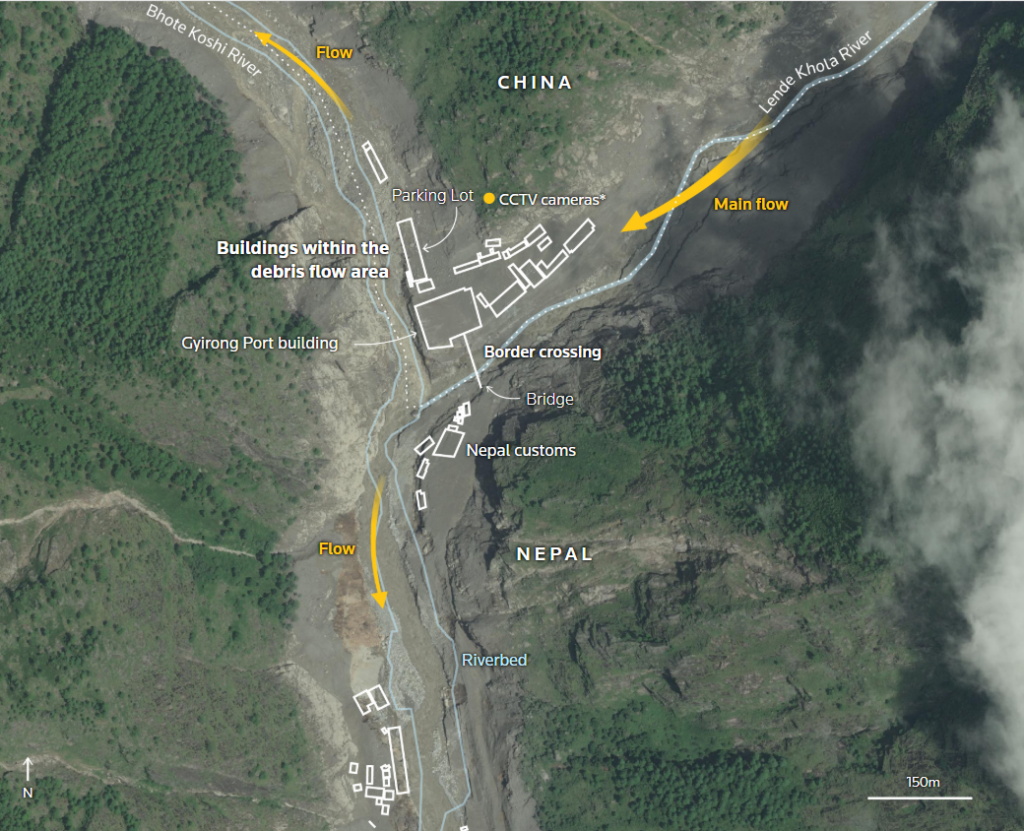
In response to the narrative of a “Chinese dam collapse” claimed in this false information, after verification, the completed water conservancy projects in Xizang’s Gyirong County mainly include dike and river regulation projects, hydropower generation projects, as well as irrigation and farmland water conservancy projects. Among them, the only hydropower station located in the county’s Xigaze Prefecture, the Gyirong Port Hydropower Station, is located in the middle and lower reaches of the Gyirong Zangbo River main stream. It is a diversion-type hydropower station (with a total installed capacity of 4,000 kW), which has no large reservoir capacity and does not involve high dams and large reservoirs in the traditional sense. No information related to the collapse of this hydropower station has been found in public disclosures, so the available evidence does not support the claim that “a dam in China has collapsed”.
This disaster was triggered by the collapse of a high-mountain glacier on the Nepal side, which formed a debris flow that poured down along the river valley, impacting various engineering facilities along the route including hydropower stations. In this incident, the hydropower stations were the affected entities rather than the cause of the disaster.
3. How Was a Fabricated Causal Chain Manufactured in 30 Minutes?
The account uses text to fabricate the false narrative of “China ‘s dam collapses”, constructing a false causal chain of “China’s dam collapses → Nepal suffers from flash floods and personnel injuries “. When video footage and casualty figures are embedded in the causal chain, the audience is easily misled by the narrative logic of “there are images, data, and events”, forming the cognition that there is a correlation between the three, but in fact, there is no factual connection supported by evidence between this information.
The post uses port surveillance video as a visual anchor.
As the Gyirong Port shown in the footage is a real geographical landmark, coupled with the widespread circulation of this video on social media, its credibility has been objectively enhanced. Meanwhile, this visual information has also served as a visual anchor for the narrative of “the collapse of a Chinese dam”, leading some audiences to misjudge the authenticity of the incident. The so-called “collapse of a Chinese dam” is hereby presented as the apparent origin of the accident chain, providing a false attribution framework for the relevant footage and data.
This post did not specify the source of the data
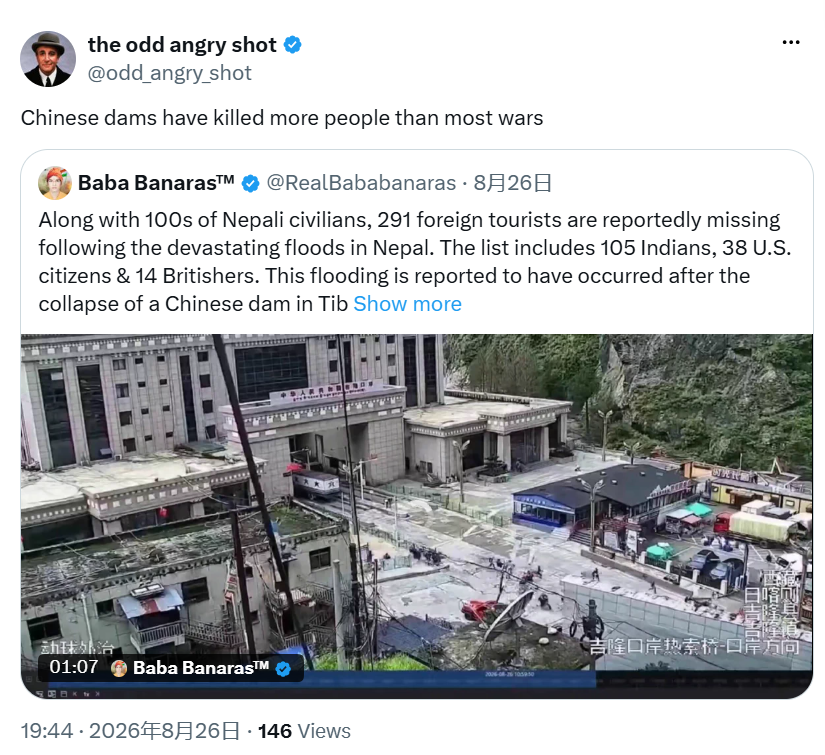
In a post made on August 26, 17:05 (Beijing Time), the Nepal Tourism Board, via its X account @nepaltourismb, posted that a total of 291 foreign tourists have gone missing, including 105 Indians, 3 U.S. citizens and 12 British nationals. The post by @RealBababanaras at 18:41 states: “291 foreigners are reportedly missing following the devastating floods in Nepal. The list includes 105 Indians, 38 U.S. citizens & 14 Britishers (sic).” The post uses the same total number of missing people (291) and Indian nationality data (105), but did not specify the source of the data. And there is a significant deviation between the number of American and British nationals and Nepal’s official data – from 3 to 38 and from 12 to 14, respectively.
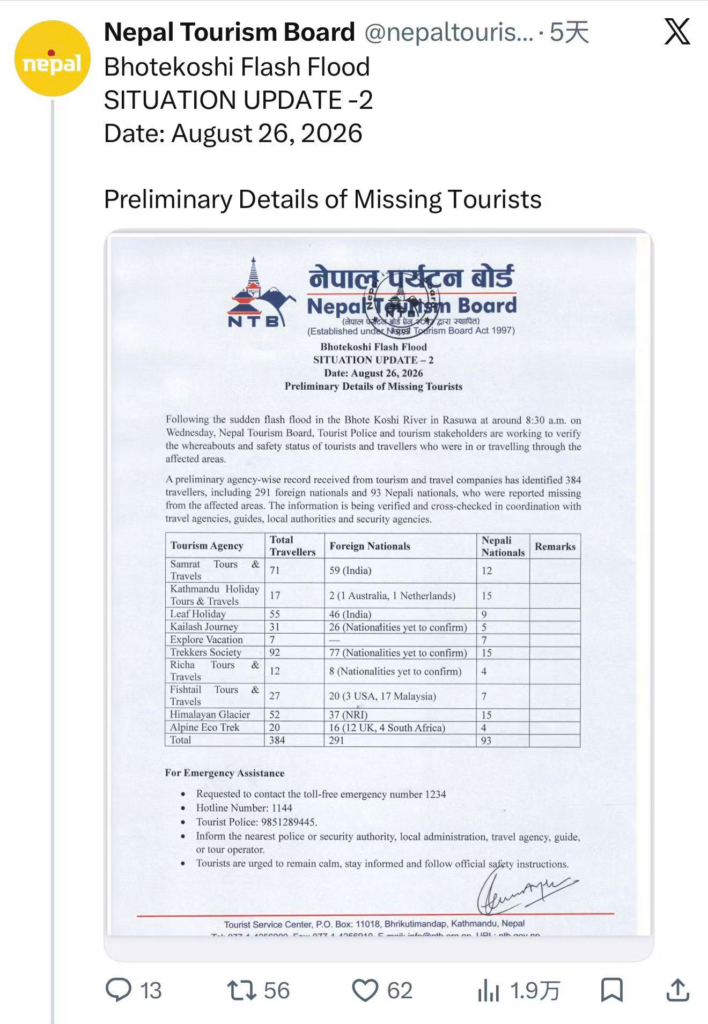
The post presumes Chinese responsibility in reverse by taking the Ni-based disaster situation as the “result”
The post juxtaposes the disaster situation and the number of missing persons in Nepal with footage from the Gyirong Port, seeking to perpetuate an impression among readers that “the casualties are related to China”. Its underlying logic is taking the disaster consequences within Nepal as the “result” and inferring in reverse that the Chinese side’s project is the “cause”, which constitutes a typical case of reverse causality.
4. Account Analysis
X platform user @RealBababanaras has approximately 177,000 followers. The account’s profile claims to be “source-based news”, indicating that it is not a formal news media organization; it also labels itself as “sometime sarcasm”, suggesting that its content may contain non-objective elements. In addition, the account’s introduction also includes “religion in India” and “Jai Hind – Jai Hind Ki Sena” — the latter, a Romanized transliteration from Hindi, means “Victory to India — Victory to India’s Army”, and is also the title and lyrics of a famous Indian patriotic song, which is often played at military parades and on patriotic occasions.

Further verification revealed that among the associated accounts of this account, there exists a verified account @BabaBanaras_IND with a similar ID format and the same profile picture. Created in April 2020, this account has approximately 28,800 followers, and the remark “Friendship with China is suicidal” once appeared in its historical posts.

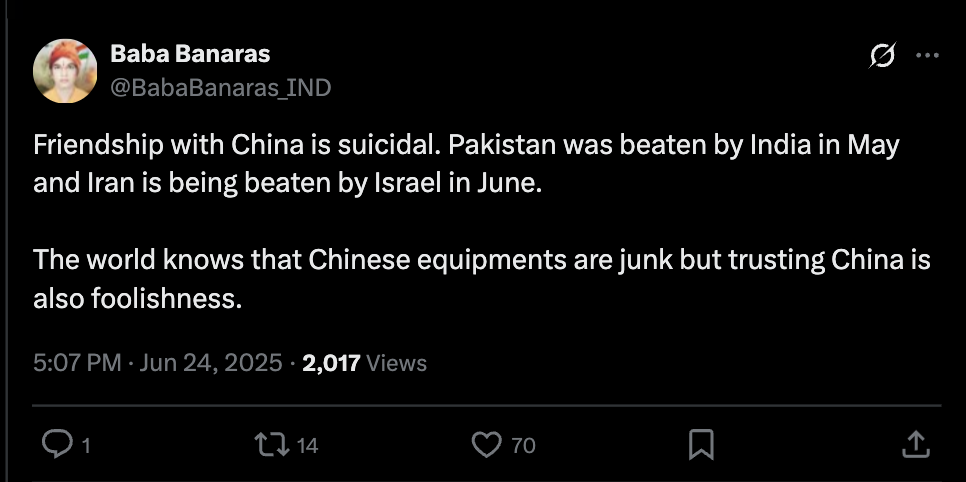
5. Actual Causes of Disasters
Cross‑verification of the reports indicates that multiple authoritative sources, including U.S., Chinese, and Nepalese geological and disaster management agencies have reached a nearly unanimous conclusion. The disaster was triggered by a glacial collapse in high‑altitude areas.
On August 26, the earthquake monitoring system of the U.S. Geological Survey (USGS) recorded a 4.4-magnitude earthquake near the border between Nepal and China.
Subsequently, the USGS released a revised analysis stating that the seismic signal was not an earthquake, but rather a secondary vibration triggered by a glacier collapse and a landslide-induced debris flow, and that no earthquake had occurred prior to the disaster. On August 27, the USGS further confirmed that a glacier collapse in Nepal and the Xizang region of China caused seismic activity, as well as catastrophic flash floods and debris flows.
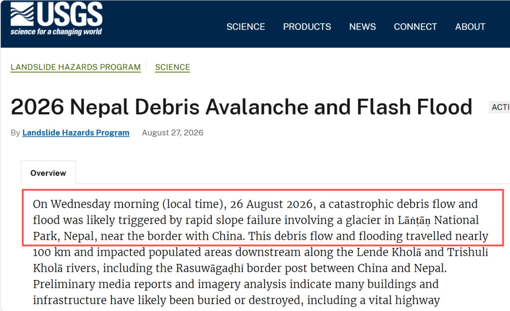
On August 27, CNN reported that Prakash Pokharel, a geologist at Nepal’s National Disaster Risk Reduction and Management Authority who had reviewed Planet Labs satellite imagery, stated that the ice-rock collapse on the Nepal side was the cause of the flash flood. In a subsequent report, CNN released a comparison of Planet Labs satellite images, showing that a large section of ice near Langtang Lirung had undergone significant changes before and after the disaster.

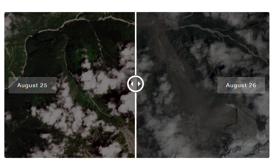
On August 28, the Ministry of Natural Resources of China stated that the disaster was triggered by the collapse of a high-altitude glacier within the territory of Nepal.
According to the “Rasuwa-Bhotekoshi Flood: Search, Rescue and Relief Response — Situation Report #01” released by the National Disaster Risk Reduction and Management Authority (NDRRMA) under the Ministry of Home Affairs of the Government of Nepal, a large-scale ice-rock collapse occurred on August 26 in Bhote Koshi watershed, about 20 km upstream of Rasuwagadhi. Preliminary analysis of high-resolution satellite imagery indicates that the event originated on a north-facing slope near the Lhende River, where approximately one kilometer of rock glacier material detached and slid rapidly downhill. The detached ice mass and rock debris formed an ice-rock avalanche debris flow, which, after entraining loose proglacial sediments along its path, further transformed into a sediment-laden flow and debris flow.
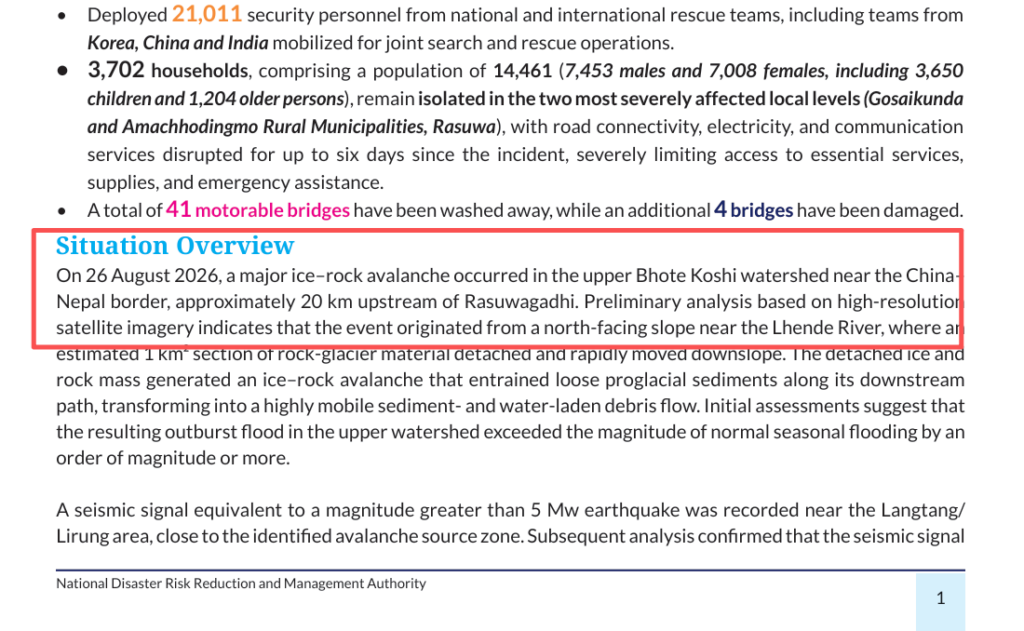
Multiple sources including the U.S. Geological Survey, the Ministry of Natural Resources of China, the Nepal National Disaster Risk Reduction and Management Authority, and media experts have reached a consistent conclusion on the cause of this disaster: that it originated from the instability of glaciers in high-altitude areas, where collapsed materials entrained moraines and other sediments to form debris flows, which then evolved into mudflows or floods and caused cross-border impacts. None of the above sources listed the collapse of an engineering dam in China’s Xizang region as a cause of the disaster.
6. How does disaster-related misinformation spread to become a public issue?
Fact Hunter further consulted Professor Kang Qiujie from Communication University of China on how disinformation evolves in the wake of sudden disasters. She analyzed that the spread of such disinformation centers on conspiracy theories as its core narrative. It frames a natural disaster as a ” Chinese dam collapse”, offering the public a clear attribution to make sense of their confusion over the disaster. Before authoritative investigation findings are released, this simplistic narrative often enjoys a greater edge in dissemination than cautious responses like “the cause is under investigation”.
1) Emotional drive is the core driver for misinformation to achieve referral
In disaster scenarios, audiences’ emotional sensitivity increases. Content with high emotional arousal serves the dual functions of information transmission and emotional expression, and boasts a higher diffusion coefficient in communication networks. Meanwhile, the recommendation logic of social media based on emotional resonance further enables the continuous spread and evolution of similar disinformation among audiences.
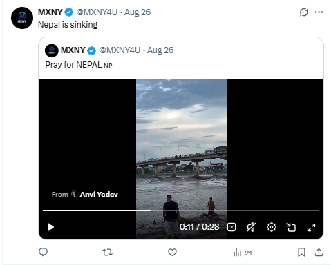
The spread of this disinformation also exhibits the aforementioned characteristics. After the account @RealBababanaras published the post, user @InputStudy left a comment saying, “That’s deliberate”, while user @MXNY4U used emotional phrases such as “Nepal is sinking”.

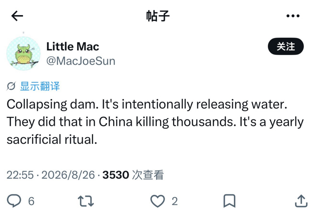
In a quote retweet, user @odd_angry_shot used the same narrative, claiming that “Chinese dams have killed more people than most wars”, while user @MacJoeSun stated that ” Collapsing dam, it’s intentionally releasing water”.
2) Disinformation presents a scattered multi-level communication pattern
Disinformation does not rely on a single channel;instead, it leverages the multiple nodes of social media to, in the interplay of posting, reposting and commenting, form a multi-level dissemination model. This scattered structure effectively avoids the disruption risk caused by the deletion of a single account or a single post; even if one node is banned, other nodes can still continue to spread the content.
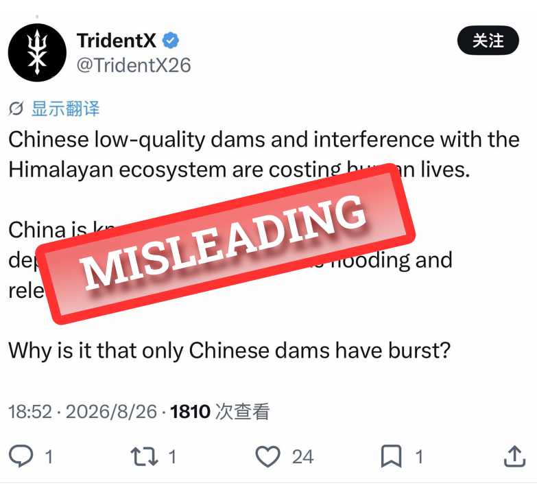
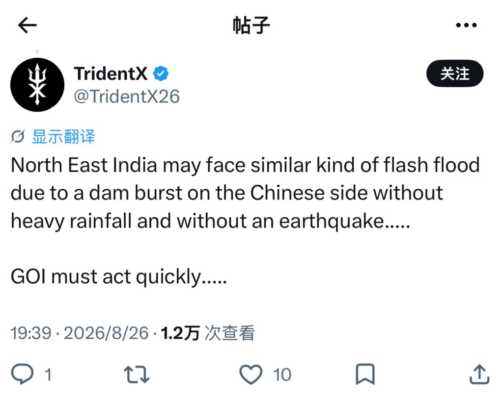
In this case, user @BlacksmithIndie @RealBababanaras @odd_angry_shot used the same narrative to post a post or comment. In the comment area , the account @TridentX26, whose IP is located in India , also uses the narrative of “China’s dam collapse causes floods” to call on the government to take action with an emotional expression of “India faces the possibility of flash floods”.

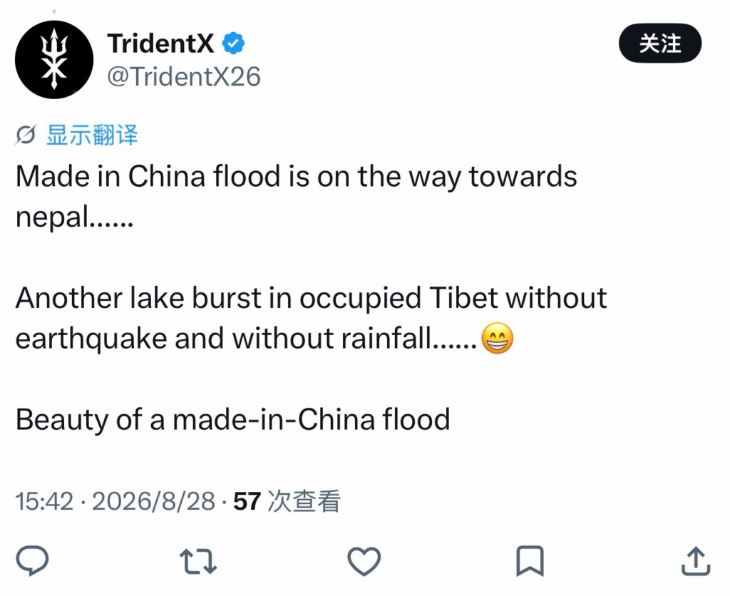
Further verification found that in other posts published by @RealBababanaras, the account @TridentX26 also appeared in the comment section and used the expression “China-made floods”.
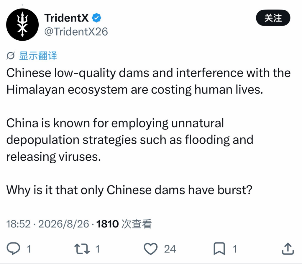
Additionally, the account @BlacksmithIndie also posted at 19:27 on August 26 (BJT) a post, claiming that ” a dam collapse in Tibet, China triggered a flood”. The post reposted by this user also mentioned that “400 pilgrims have gone missing”, but did not specify the source of the data.
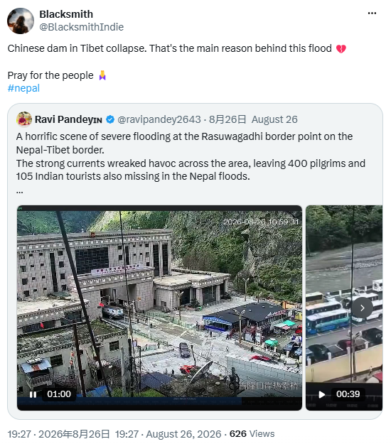
It is worth noting that the X user with an ID address located in India @ravipandey2643 claims in their profile to be a journalist, but also states that “all tweet are presonal”.

3) Scattered topics are upgraded to public hotspots
When certain posts attract attention due to their topicality, users on social media platforms follow up by reposting, commenting on, and reworking them, which gradually brings together the originally scattered topics and escalates them into hot events of public concern.
In this case, @RealBababanaras has approximately 177,000 followers. As of September 6, the two pieces of disinformation about “Chinese dam collapse” have accumulated 640,000 views, received 323 comments, and been reposted 418 times in total; the related reposts have garnered around 250,000 views combined, making this account a key node in this narrative.
It should be noted that the claim of “Chinese dam collapse” is not a newly fabricated piece of disinformation that emerged only in this disaster, but a long-standing and repeatedly used false narrative framework.
To examine this persistent narrative, the Fact Hunter team consulted Professor Tang Jingtai from the Department of Communication, School of Journalism, at Fudan University.According to Professor Tang’s verification and analysis , the core AI video underpinning the “Chinese dam collapse” narrative can be traced back to at least May 2026, when it circulated on Facebook and Instagram. The same set of AI-generated videos was distributed from the shared Content Pool to multiple platforms including X, Instagram, Facebook, TikTok and YouTube.On the X platform, other spreading accounts include @arashi_flame on August 26, as well as @ashokshera94 and @Ayesha0Khaan on August 27. @TridentX26 carried out localization of this narrative, claiming that northeast India is also threatened by Chinese dams. On Facebook, an AI-generated missile attack video posted by user “Samuel Nato” received about 1.8 million views, boosting the formation of a cross-platform dissemination peak on August 27.Content uploaded by original creators and multilingual reposters can also be found on TikTok and YouTube. Some posts also cite the fictional “Japanese media confirmation”, or splice real surveillance footage of the Gyirong Port from the Associated Press and China Media Group(CMG) into AI-generated clips, creating a false impression that multiple sources corroborate one another.
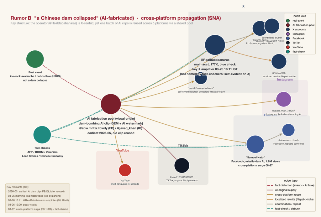
Following the recent flash flood and debris flow disaster at the Gyirong Port, this long-dormant false narrative has been reactivated and spread rapidly by capitalizing on the sudden incident. The aforementioned posts, together with the AI-generated video, constitute the key nodes of this narrative, gradually bringing together and superposing the originally scattered topics, which eventually escalated into a public hot-button issue.
7. How can the general public spot disinformation faster?How can we more quickly see through the disguises of disinformation on social media?
Professor Kang Qiujie from the School of Information and Communication, Communication University of China, analyzed and stated that the high deceptiveness of this piece of disinformation mainly stems from its “false causal chain”, namely “the collapse of the Chinese side’s dam → flash floods hitting Nepal and resulting in casualties “. Both the disaster and the casualties are real events, and the only variable that has been tampered with is the “attribution” link: the disaster caused by natural or objective factors is presented as being caused by a Chinese infrastructure project.
To quickly spot such rumors, one can use the “CRAAP Test” framework from the UNESCO Media and Information Literacy Guidelines, which covers five dimensions: Currency, Relevance, Authority, Accuracy, and Purpose.
Specifically in this case, the three dimensions of authority, accuracy and purpose are particularly critical, which clearly reveals the process of false information losing ground at every level.
lack of authority. The videos cited in this false narrative are not marked with any source, nor are there any verifiable original footage or data provided to support them, which means they lack basic traceability of information sources.
Lack of accuracy. In the communication chain, commenters and reposters pair the content with highly emotional text, which stirs up fear and anger among the audience. Emotional expressions that deviate from facts not only weaken the public’s willingness to conduct rational verification, but also grant false information a communication power far exceeding that of objective facts.
It has a clear purpose. The core intention of disinformation is to make the audience accept a fabricated conclusion. This pseudo-causal chain starts with “the collapse of a Chinese dam”, and after multiple rounds of processing, the information forms a closed narrative loop that connects from beginning to end. This structure reduces the audience’s willingness to verify each link one by one, making the overall conclusion easy to be accepted in a general way.
Verdict
Misleading
Conclusion
After verification, the online claim that “the collapse of a dam in Tibet has caused flash floods in Nepal” is inconsistent with the facts.
Within 24 hours after the disaster, the difficulty of cross‑border verification inevitably prolonged the “fact gap”, creating room for false attribution.The video attached to the post was confirmed through comparison to be the actual disaster situation at the Gyirong Port in Xizang; the footage contains no dam or dam break process, and had its time watermark removed and background music added before release. Within 30 minutes, both posts anchored claims on footage of Gyirong Port and falsely attributed the disaster to infrastructure on the Chinese side — a clear case of reversed causality.The account that posted the content is not a news outlet and has spread China‑related misinformation. The disaster was a debris flow from a glacial collapse on the Nepal side, confirmed by USGS, China’s Ministry of Natural Resources, Nepal’s NDRRMA, and experts. The upstream hydropower station is a diversion type with no large storage; no dam collapse is recorded. The claim was driven by emotional expressions and spread in a fragmented, multi‑layered manner during the disaster, with the two related posts accumulating about 630,000 views and the related reposts about 250,000 views. The “Chinese dam collapse” narrative is old; AI videos from May 2026 were reactivated now. The claim fails the UN CRAAP test on authority, accuracy, and purpose.
To sum up, the online claim that “the collapse of a Chinese dam caused flash floods and casualties in Nepal” is a misleading narrative, a patchwork of real footage and false attribution that obscures the broken causal chain. Cross-border rescue efforts are still ongoing, and all parties concerned should focus on life search and rescue as well as post-disaster reconstruction; the public should remain cautious about information with unknown sources, strong emotional overtones or leaps in logic.
Background
On August 26, 2026, a glacier collapse in Nepal’s Rasuwa area triggered a massive flash flood and debris flow along the China-Nepal border, resulting in significant casualties in both countries. Within hours of the disaster, Chinese President Xi Jingping ordered all-out search and rescue efforts for those missing in the disaster. He stressed the need to strengthen monitoring and early warning, ensure scientific rescue operations and guard against secondary disasters. Meanwhile, the National Disaster Reduction Commission of China and the Ministry of Emergency Management immediately launched a national Level II emergency response for disaster relief, and urgently allocated 30,000 pieces of central disaster relief materials; the Ministry of Finance pre-allocated 120 million yuan of central disaster relief funds; Xizang Autonomous Region simultaneously launched a Level I emergency response for rescue, and dispatched a total of more than 1,000 people to the front line to make every effort to carry out the transfer and resettlement of affected people.
Meanwhile, Nepal also moved quickly to launch rescue operations. In a post titled “Regarding the Rasuwa Flood” published on his verified Facebook account on August 26, Nepali Prime Minister Balendra Shah said that the Nepal Army, the Armed Police Force (APF) and the Nepal Police had been deployed to take part in search and rescue and relief operations. A disaster update issued by Nepal’s Ministry of Foreign Affairs the same day said that following the severe flash flood on the Bhotekoshi River, security and disaster management agencies, local governments and health services had been fully mobilized to carry out search and rescue, evacuation, emergency medical assistance and relief operations, while closely monitoring the river system and downstream flood risks. The same day, the Office of the Prime Minister and Council of Ministers opened the Prime Minister’s Disaster Relief Fund and appealed to the public for donations.
Have a questionable video or claim? Submit it to Fact Hunter’s investigation team at [ therealfacthunter@outlook.com ].
Primary Fact Checker: Ai Lingxuan,Lei Ting
Secondary Fact Checker: Liao Qin
References:
https://m.thepaper.cn/detail/33955166
https://www.swissinfo.ch/chi/usgs
https://www.usgs.gov/programs/landslide-hazards/science/2026-nepal-debris-avalanche-and-flash-flood https://m.thepaper.cn/detail/33955166
https://www.swissinfo.ch/chi/usgs
https://www.usgs.gov/programs/landslide-hazards/science/2026-nepal-debris-avalanche-and-flash-flood
https://www.cnn.com/2026/08/26/world/live-news/nepal-flash-flooding-floods-intl
https://www.nytimes.com/2026/08/26/world/asia/nepal-flood-glacier-
https://www.mem.gov.cn/xw/yjglbgzdt/202608/t20260826_708718.shtml
https://news.cctv.com/2026/08/26/ARTIudqcivA8kZ0eeQtuCuRj260826.shtml
https://www.chinanews.com.cn/gn/2026/08-29/10686492.shtml
https://app.xinhuanet.com/news/article.html?articleId=202608309c9e52d2eca34b62a63075a28f86ea0c
https://www.mfa.gov.cn/web//wjdt_674879/zwbd_674895/202608/t20260831_12012999.shtml[reference:57]
http://www.mem.gov.cn//xw/yjglbgzdt/202608/t20260826_708718.shtml
https://m.gmw.cn/2026-08/30/content_1304556385.htm%5Breference:60%5D
http://www.xinhuanet.com.cn/politics/20260827/59f3c8513045473a918c7c423e0f063b/c.html
https://www.reuters.com/graphics/NEPAL-FLOODS/MAP/byvrdywwlve/
https://slt.xizang.gov.cn/slxw/slyw/201612/t20161201_229642.html
https://www.usgs.gov/programs/landslide-hazards/science/2026-nepal-debris-avalanche-and-flash-flood
https://www.internazionale.it/ultime-notizie-reuters/2026/08/27/glacier-collapse-may-have-triggered-deadly-nepal-flash-flood-experts-say
https://kathmandupost.com/national/2026/08/26/ice-avalanche-debris-lake-may-have-triggered-bhotekoshi-flood?utm_
https://www.cgs.gov.cn/ywdt/ddyw/202608/t20260828_867531.html
https://ndrrma.gov.np/mediafiles/rasuwa/Rasuwa_Flood_SitRep_Temp_ENG_01_01092026.pdf?utm_so
https://ndrrma.gov.np/np/situation-report/395?fbclid=IwY2xjawUK9YxwZG9mAWV4dG4DYWVtAjEwAGJyaWQRMWxuSTdwc09IUUVUSk1EZ0lzcnRjBmFwcF9pZBAyMjIwMzkxNzg4MjAwODkyAAEeReaPy86N9Vrq3_sMQ0sX0L90yMkheT7xbPJLLbwQ0yMYU5XhWjOuQdtBygQ_aem_F2-QyyyBdEPPTQhZluIUUQ
https://www.cgs.gov.cn/ywdt/ddyw/202608/t20260828_867531.html
https://news.sciencenet.cn/htmlnews/2026/8/570400.shtm
https://www.facebook.com/balenOfficial/posts/1641705497321699/
https://opmcm.gov.np/content/592/a-heartfelt-appeal-to-all-to-provide/
https://mofa.gov.np/content/1865/latest-updates-on-flash-floods–26-august/
https://www.facebook.com/balenOfficial/posts/1641705497321699/
https://opmcm.gov.np/content/592/a-heartfelt-appeal-to-all-to-provide/
https://mofa.gov.np/content/1865/latest-updates-on-flash-floods–26-august/